World's Highest Mountains
Top 10 Mountain Ranges in the World

Mountain ranges occur on every continent. Here are some of the Earth's highest, longest, and most famous ranges. In this Top Ten List, we are going to start with the ranges with the highest peaks (including four sub-ranges of the Himalayan system), move on to some of the longest ranges, and end with a few mellow old ranges on quiet continental margins.
Great Mountain Ranges
(click column header to sort results)
Name
|
Continent
|
Highest peak
|
Peak height (ft)
|
Peak height (m)
|
Length of range (mi)
|
Length of range (km)
|
|---|---|---|---|---|---|---|
| Himalayas | Asia | Mount Everest (Sagarmatha, Chomolungma) | 29,029 | 8,848 | 1,500 | 2,400 |
| Karakoram | Asia | K2 | 28,251 | 8,611 | 300 | 500 |
| Hindu Kush | Asia | Tirich Mir | 25,289 | 7,708 | 600 | 950 |
| Pamir | Asia | Ismoil Somoni Peak (Stalin Peak, Communism Peak) | 24,590 | 7,495 | 200 | 300 |
| Tien Shan | Asia | Jengish Chokusu | 24,406 | 7,439 | 800 | 1,300 |
| Andes | South America | Aconcagua | 22,838 | 6,961 | 4,300 | 7,000 |
| Alaska Range | North America | Denali (Mount Mckinley) | 20,322 | 6,194 | 400 | 650 |
| Caucasus | Europe/Asia | Mount Elbrus | 18,510 | 5,642 | 680 | 1,100 |
| Alps | Europe | Mount Blanc | 15,780 | 4,810 | 750 | 1,200 |
| Transantarctic Range | Antarctica | Mount Kirkpatrick | 14,856 | 4,528 | 2,200 | 3,500 |
| Rockies | North America | Mount Elbert | 14,440 | 4,401 | 3,000 | 4,800 |
| Great Dividing Range | Australia | Mount Kosciuszko | 7310 | 2,228 | 2,200 | 3,500 |
| Urals | Asia/Europe | Mount Narodnaya | 6217 | 1,895 | 1,600 | 2,500 |
Why Are There High Mountain Ranges in Asia?
The earth’s surface is constantly moving, a few centimeters a year, with continents riding the drifting geologic plates. Where the plates collide, under or next to a continent, the crust thickens into mountains. Continental and ocean-floor rocks are crumpled and thrust over each other, sometimes along with slices of the mantle from under the ocean floor, and often pierced with volcanoes that erupt masses of molten material squeezed out of deeply buried crust.
As shown in the map below, all south-central Eurasia is festooned with mountain ranges. A succession of smaller landmasses slamming into the southern edge of Eurasia have raised up many mountain ranges: the Himalayan complex, the Tien Shan, the Caucasus, and the Alps, among many others.
As shown in the map below, all south-central Eurasia is festooned with mountain ranges. A succession of smaller landmasses slamming into the southern edge of Eurasia have raised up many mountain ranges: the Himalayan complex, the Tien Shan, the Caucasus, and the Alps, among many others.

I. The Himalayan Mountain System
In south-central Asia, the ongoing collision between the Indian Plate and the Asian plate has raised up the world's most mountainous area, the Himalayan orogenic belt. The area began rising in the last 50 million years ago and continues to rise at about 5 mm a year as the collision continues. Since both plates were covered with lightweight continental crust, which tends to float on top of the heavier mantle layer, crust from both plates was crumpled together. In addition, the ocean floor between the two moving continents was swept up and and stacked between them. The top of Mount Everest itself is sedimentary rock from the ocean bottom.
The Himalayan region contains the world's greatest accumulation of ice outside the Arctic and Antartctic. The world’s hundred tallest peaks are nearly all in the Himalayas, Karakoram, Pamirs, or Hindu Kush. (A few exceptions are also in southern Asia, in China's Hengduan Mountains and Kunlun Shan.) The world's fourteen 8000-meter peaks are all in the Himalayas proper or the Karakoram.
The Himalayan region contains the world's greatest accumulation of ice outside the Arctic and Antartctic. The world’s hundred tallest peaks are nearly all in the Himalayas, Karakoram, Pamirs, or Hindu Kush. (A few exceptions are also in southern Asia, in China's Hengduan Mountains and Kunlun Shan.) The world's fourteen 8000-meter peaks are all in the Himalayas proper or the Karakoram.
 on down, the hundred tallest are in Central Asia.")
1.A. The Himalaya Range
The Himalaya Range (meaning "home of snow"), stretching from Pakistan to Bhutan, separates the Indian subcontinent from the Tibetan Plateau. The world's highest peak, Mount Everest, at 29,029 feet, is in the Himalayas, as are scores of massive, beautiful, dangerous peaks climbers have given their lives to ascend. Their snowfields supply great rivers: the Ganges, the Indus, and the Brahmaputra.
Snowy Mountains Provide Lifeblood for Agriculture

I.B. Karakoram Mountains
The Karakoram (meaning "black gravel") Mountains of Pakistan mark the western end of the greater Himalayan mountain chain and contain the greatest concentration of high peaks on earth. The Karakoram is a mountain desert: a vast region of barren rock and ice, of gravel-covered glaciers where jeep roads cut through valley systems to remote villages still many days' walk from the high mountains.

1.C. Hindu Kush
The Hindu Kush, part of the Himalayan complex, is a group of ranges in Afghanistan and Pakistan. The name is said to mean either "border of India" or "killer of Indians." The Khyber Pass crossing it, connecting Afghanistan with Indian and Pakistan, has long been of great military importance, including during the 21st-century invasion of Afghanistan by the US.

I. D. Pamir Range
The Pamir Range, in Pakistan, Afghanistan, and Tajikistan, trends more north-south than the other Himalayan ranges. The ancient Silk Road, the long and dangerous land route between China and Europe, crossed it. Its highest peak is 24,590-foot Ismoil Somoni Peak, at one time called Stalin Peak, then Communism Peak.

II. Tian Shan
The Tian Shan (or Tien Shan) continues eastward from the Hindu Kush into China and is separated from the Himalayan ranges and Tibet to the south by the huge Taklimakan Desert in the Tarim Basin. The Tian Shan marks the northern boundary of another microcontinent that rammed into the southern edge of Asia before India did. Compression in the area is lifting the range up.
The Snow-Topped Tian Shan

III. Andes Mountains
The world's longest mountain chain, and the highest outside Asia, is the Andes, running 7000 miles from Colombia to the southern tip of South America. Unlike the Asian mountain ranges discussed earlier above, which resulted from collisions between continents, the Andes are a result of plates bearing ocean crust colliding with the continent of South America. Since the Cretaceous period (about 65 million years ago, the time of the dinosaurs), ocean crust has been sliding below the west coast of South America, sinking, melting, and causing volcanoes and uplift. The Andes are part of the "Rim of Fire" surrounding the Pacific, marked by volcanoes, earthquake zones, and deep ocean trenches. The glaciers and snowfields of the Andes supply water to the arid coast of central South America as well as to the Amazon Basin.
The Andean peak Aconcagua, like Everest, is one of the Seven Summits, that is, it is the highest peak on its continent.
The Andean peak Aconcagua, like Everest, is one of the Seven Summits, that is, it is the highest peak on its continent.
Andean Glacial Scenery

IV. Alaska Range
The Alaska Range is a long, narrow, curved range that traverses Alaska from the Aleutian Peninsula to the Yukon Territory. In its bend in Central Alaska, it has the highest mountain in North America, 20,237-foot Denali (Mt. McKinley), one of the Seven Summits (as the highest mountain in North America), and one of the world's tallest mountains from base to top. Geology here is complex; like much of the western margin of North America, Alaska is made of strips of continents that came from somewhere else. In Alaska, the faults that bound the strips have been bent, so that Denali, made of lightweight granite, popped up at the corner, under pressure from a subduction zone far to the south in the Gulf of Alaska. It dominates the surrounding peaks and is visible from great distances, seeming to float above its surroundings.
Denali in the Alaska Range

V. Caucasus Range
The Caucasus are another Eurasian range that resulted from a subcontinent, the Iranian Plate, running into the Eurasian land mass. The range is visible in the Central Asia map above as a linear feature between the Black Sea and Caspian Sea. Volcanism surged in the area in the last few million years, creating volcanic peaks like Mt. Elbrus (18,510 feet), the highest mountain in Europe and one of the Seven Summits.
Wildflowers in the Caucasus

VI. The Alps
Another range formed by an approaching continent (Africa) smashing into Eurasia, along with great sheets of the sea floor, beginning about 50 million years ago. Stretching around Northern Italy from Monaco through France, Switzerland, and Austria to Slovenia, the Alps contain many huge flat-lying folds called nappes, in which rocks from the vanished ocean Tethys are stacked on top of European rocks, and in turn covered by rocks from Africa. The European pastimes of geology and mountain-climbing originated in large part in the Alps in the 1700s and 1800s.

VII. Transantarctic Mountains
The Transantarctic Mountains deserve mention, in part because they are are long, 2200 miles. They run from McMurdo Sound, the base of 19th century Antarctic exploration, in a gentle S-shape across the continent to the Weddell Sea. They are an old range, 500 million years old, far back in the past as plate collisions go. They are largely covered with snow and ice; only their tallest peaks poke out of the ice as nunataks. Robert Scott's expedition geologized there, finding sedimentary rocks including coal, full of plant fossils. The range is also home to the Dry Valleys, sheltered glacial valleys containing the few patches of bare soil on the continent. Although Antarctica has one of the Seven Summits (Mount Vinson, 16,050 ft), it is not in the Transantarctic Mountains, but the younger Ellsworth Mountains.
Beardmore Glacier, Transantarctic Range

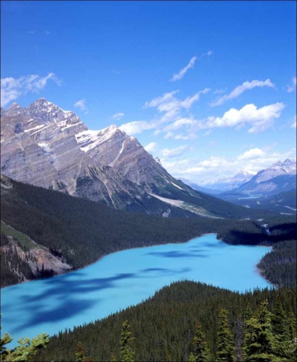
VIII. Rocky Mountains
The Rocky Mountains are another long range, extending more than 3,000 mi (4,800 km) from northern Mexico to Alaska; Mt. Elbert (14,431 ft/4,399 m) in Colorado is its highest peak. The Rockies are located between the Great Plains on the east (from which they rise abruptly for most of their length) and a series of broad basins and plateaus on the west.
For a long time, plate tectonics had no good explanation for the Rockies' existence. They are not obviously a plate margin; for much of the range's history the plate boundary has been far to the west, along the western edge of the continent. One explanation (for example, in Keith Heyer Meldahl's book This Rough-Hewn Land) is that much of the Farallon plate formerly to the west has been dragged underneath western North America, and its slowly melting remnants are supporting the Rockies and the Colorado Plateau.
For a long time, plate tectonics had no good explanation for the Rockies' existence. They are not obviously a plate margin; for much of the range's history the plate boundary has been far to the west, along the western edge of the continent. One explanation (for example, in Keith Heyer Meldahl's book This Rough-Hewn Land) is that much of the Farallon plate formerly to the west has been dragged underneath western North America, and its slowly melting remnants are supporting the Rockies and the Colorado Plateau.
The Scenic Rocky Mountains
IX. Australia's Great Dividing Range
The Great Dividing Range is a long, rather old mountain range (from the Carboniferous, 300 million years ago) with complex geology, running from Queensland to New South Wales. Its Snowy Range gets winter snow, has alpine scenery, and contains the highest point in Australia, Mt. Kosciuszko at 7,310 feet. As the highest point on a continent, it makes the list of the Seven Summits, if you do not include New Guinea's Punczak Jaya instead (16,024), as the highest point in the region of Oceania.

X. Ural Mountains
The Ural Mountains extend for 1600 miles from the hot Kazakh steppes to the frozen coast of the Arctic Ocean. The Urals are old mountains--250 to 300 million years—and were formed at the boundary between two plates when Kazakhstania collided with Laurussia. Their highest peak is Mount Narodnaya at 6,217 feet.
The Snow-Topped Ural Mountains

Mountain Ranges of All Kinds
These are some of the world's tallest and longest ranges. But even the lesser ranges provide beauty, adventure, solitude, wildlife habitat, and water. In closing we are going to vist a couple of less spectacular ranges that nevertheless are beautiful.
Bonus Range: The Serra do Mar of Brazil
I'd like to include a couple old, low ranges from Gondwanaland (the southern hemisphere), that don't record any recent great tectonic collisions, but do provide scenery, waterfalls, and water supplies. Brazil's coastal mountains run from Espiritu Santo to Santa Catarina, along the Atlantic Coast. They are more of a discontinuous escarpment than a mountain range.
The Serene Brazilian Coast Range

Bonus Range: Eastern Ghats
The Eastern and Western Ghats--escarpments at the edge of a stable continent--form the edges of the Deccan Plateau in southern India. The Eastern Ghats extend about 700 mi (1,100 km), with an average elevation of about 2,000 ft (600 m), and the Western Ghats run some 800 mi (1,300 km) along the southwestern and western coast, with average elevations from 3,000 ft (900 m) to 5,000 ft (1,500 m). Because they receive heavy rainfall during the monsoon season, the Western Ghats are peninsular India's main watershed.
Mellow Scenery of the Eastern Ghats


%20on%20down,%20the%20hundred%20tallest%20are%20in%20Central%20Asia.)
%20on%20down,%20the%20hundred%20tallest%20are%20in%20Central%20Asia.&picture=https://usercontent2.hubstatic.com/11914887_f520.jpg&redirect_uri=https://owlcation.com/stem/TopTenMountainRanges)
Comments
Post a Comment